


Why Manual Data is the Weakest Link in Your Wildfire Mitigation Plan
How utilities keep GIS and asset records aligned with the field

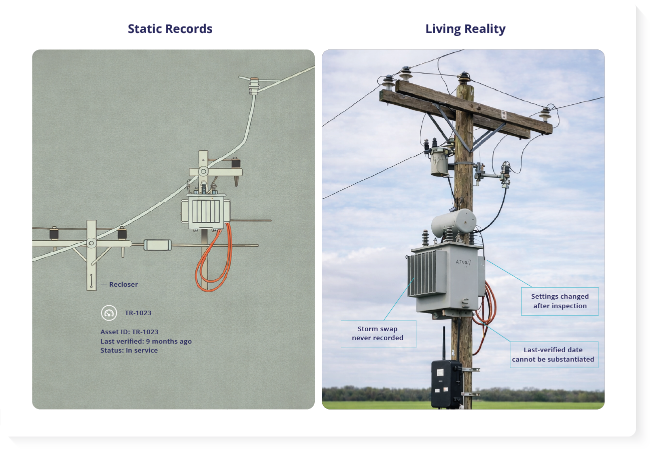
Your Wildfire Mitigation Plan is only as strong as the asset records behind it. Over time, what’s on the map can drift from what crews find in the field. If your GIS hasn’t been physically verified in months, you may be managing high-risk circuits with outdated records.
That matters because an annual Wildfire Mitigation Plan is a commitment to regulators and insurers, and your own internal review teams. The question is simple: do you know what’s on each circuit, where it is, and when it was last verified?

Automated asset discovery helps between field checks. It doesn’t replace inspections. It helps you avoid truck visits that are only needed to confirm what the record should already show. It surfaces mismatches and missing fields early, so field checks are more targeted and reviews are easier.
What This Solves
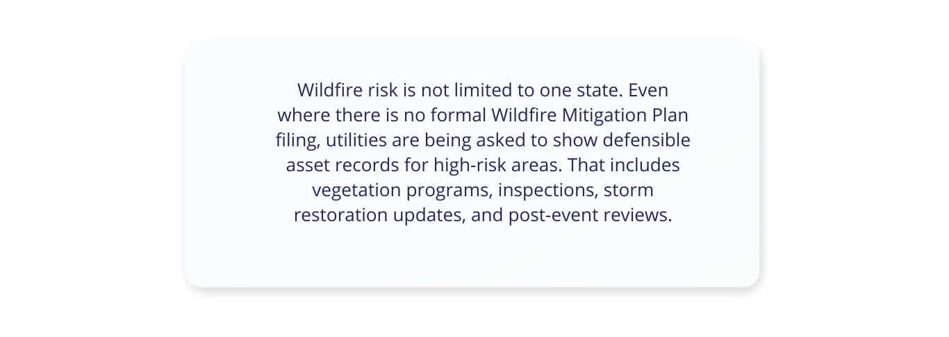
Wildfire scrutiny is rising in many regions, not just California. This article explains why utility asset records fall behind the field and how that slows mitigation work. You’ll learn how to flag mismatches across GIS, work orders, and inspection notes, and how to focus field verification on the records that truly need it.
Wildfire Mitigation Plan Records Are Only as Current as Your Last Field Check
Record drift is not a process failure. It’s what happens when normal grid work gets recorded in different systems at different speeds.
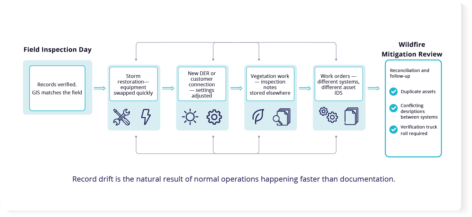
By the time field notes and work orders make it into GIS, the equipment in service can already be different again.
By “asset records,” we mean the information you track for poles, transformers, switches, reclosers, communications gear, and sensors. That includes location, labeling, last-verified date, and the settings or notes you rely on in high-risk areas.
For many utilities, those records are a snapshot in time. To meet regulatory requirements, teams send crews into designated high fire-risk areas (often called High Fire Threat Districts) to confirm what is installed. But the moment inspections end, normal operations continue and the system of record starts aging again.
A Simple Way to Target Field Verification
You don’t need to re-check everything to regain confidence. You need an exception list. A simple workflow looks like this:
- Export GIS data for the circuits and high-risk zones in scope
- Export recent work orders or CMMS changes for the same area
- Export inspection outputs or field notes tied to those structures
- Align records using circuit, structure ID, asset ID, and location
- Flag three exception types: missing, conflicting, and duplicate records
- Rank exceptions by risk and age of last-verified date
- Send crews only to the exceptions that truly require confirmation
- Update the system of record and attach evidence
This keeps field verification focused and defensible.
Changes happen as part of everyday work. New customer connections, including rooftop solar and battery systems, can drive updates to protection settings, transformers, and communications gear on high-risk circuits. If those changes are not captured consistently across systems, documentation can fall out of step with what is installed and how it is configured.
Storm response creates similar drift. Equipment is often swapped quickly to restore service, including transformers, reclosers, switches, and communications devices. Vegetation programs add inspections and work orders that may live in separate tools. When GIS, work orders, and inspection notes don’t update together, keeping records consistent becomes harder.
What “Defensible” Means in a Review
Defensible records make it easy to answer basic questions without a scramble. In practice, that usually means:
- One consistent asset ID across systems
- Correct location and circuit association
- A populated last-verified date tied to evidence
- Clear change history when equipment is swapped or settings change
- No duplicates and no orphan records
- The ability to answer: “What was installed here on a specific date?”
This matters during review. When regulators, insurers, or internal teams ask what equipment was in service at a specific location, conflicting IDs, missing last-verified dates, or duplicated records make it harder to show a defensible answer. Your Wildfire Mitigation Plan may be based on records that were accurate on inspection day, but do not match what is in service today.
What Record Drift Looks Like in Practice
Record drift usually shows up as a small set of repeat patterns:
- A work order references an asset ID that does not exist in GIS
- GIS shows one device at a location, but field notes describe another
- The same equipment appears twice under different names or IDs
- A “temporary” storm replacement stays in service but never gets recorded cleanly
- A critical asset in a high-risk zone has no last-verified date you can trust
- The only way to confirm what is installed is to send a truck
When these issues pile up, teams spend time reconciling records instead of doing mitigation work.
What It Looks Like When GIS Asset Records Don’t Match Work Orders
When systems don’t agree, teams spend time reconciling records instead of doing mitigation work. This is where verification truck rolls pile up. Common examples include:
- A work order references an asset ID that does not exist in the GIS map
- The map shows one device at a location, but inspection notes describe another
- The same equipment appears twice under different names or IDs
- A “temporary” storm replacement stays in service, but never gets recorded cleanly
- A critical asset in a high-risk zone has no last-inspected date you can trust
The only way to confirm what is installed is to send a truck.
After an event, regulators, insurers, and internal review teams ask basic questions. What equipment was in service at that location? What do your records show about it? If your systems list the wrong device, list it twice, or even miss it entirely, it is harder to show that you managed and maintained the right equipment on high-risk circuits. That is why record accuracy matters in wildfire mitigation.
Finding Assets That Are Not on Your Lists
In utilities, missing assets often still show up somewhere. A device can be active on the network, appear in cloud records, or generate logs, even if it never made it into the GIS map or an asset spreadsheet.
At this point, most teams ask the same question: How do you keep records aligned with the field without installing software on field devices or running disruptive scans?
That’s where agentless, read-only discovery comes in. It lets you see what’s present without installing anything on field equipment. You can start by uploading the exports you already have and reconciling them. If you later connect WanAware through integrations, it can keep that view fresher and also surface assets that don’t appear in your lists.
Finding Assets That Are Poorly Documented
Some assets slow teams down more than others. They are the ones where the field equipment does not clearly match the record. These assets trigger extra calls, repeat checks, and truck rolls just to confirm what is actually installed.
This usually happens during emergency storm restoration, fast hardware swaps, or rapid distributed energy work. The equipment is valid and in service. The record is what falls behind. Over time, that makes inspections harder to plan and reviews harder to defend.
How WanAware Helps With Asset Discovery
Because it’s agentless and read-only, you can do this without installing software on field devices, and without disrupting operations. Most inventory tools give you a long list. But that is not how a utility runs the grid. WanAware organizes what you upload into logical groups that match operations. Instead of forcing everything into a generic IT-style format, it lets you group assets the way your teams already run the grid.
For example, you can group assets by substation and feeder, by circuit, by wildfire risk zone, or by inspection program. When inventory mirrors how the grid is managed, it becomes easier to see what is shared, what is missing key details, and what needs verification before wildfire mitigation reviews.
With automated asset discovery, utilities can use their data to:
- Identify assets with missing or outdated version and maintenance fields in your record
- Compare recent field changes against your GIS records to see what is not yet reflected
Keep a clear record of what you uploaded, when you updated it, and who changed key fields
Seeing How Problems Spread, Not Just Where Assets Sit
A basic inventory tells you what you have. It does not help you understand what happens next when something fails.
For example, if a transformer fails, the urgent question is not only what failed. It is also who and what is affected. That can include customers, critical facilities, and services tied to that section of the network.
WanAware links related asset records so you can see shared equipment and shared equipment and related records (what connects to what), not just rows in a spreadsheet. This helps teams understand where a local problem could ripple outward, and prioritize where to investigate and harden based on likely impact.
Defensible Records Without Rebuilding Everything Each Season
Regulators and insurers are increasingly asking utilities to show evidence that asset records are accurate. “Best effort” language is not enough when the request becomes, “Show me how you know this is accurate.”
A stronger approach is to move from a seasonal snapshot to an inventory you can keep up to date as records change. This supports a steadier story over time, especially in high-fire-risk zones where change is constant.
That can support practical outcomes:
- More credible filings by showing a clearer, more up-to-date view of assets in the highest-risk areas
- Reduced exposure by limiting the chance that poorly documented equipment becomes part of an event narrative
Less time spent reconciling records before reviews.
Conclusion: From Static Lists to Living Utility Intelligence
You cannot protect a grid you cannot see clearly. Manual audits will always matter for physical maintenance, but they should not be the primary source of truth for what is in service and where it is.
Automated asset discovery helps utilities keep records aligned with the field, reduce avoidable verification work, and make wildfire mitigation documentation easier to stand behind.In the free trial, you start with uploads. As you enable integrations, WanAware can keep the view current with ongoing updates.
Where to Go Next
If you’re responsible for utility asset records, resilience, or compliance work, the Utilities industry page goes deeper on how teams address visibility gaps across the grid.
Explore how utilities use WanAware to maintain current asset records, understand risk, and support defensible reviews as conditions change.
Explore WanAware for Utilities
FAQs
What is included in a utility Wildfire Mitigation Plan?
A Wildfire Mitigation Plan typically describes how a utility reduces ignition risk in high-risk areas. That includes inspection and maintenance programs, vegetation work, corrective actions, and documentation showing what equipment is in service and when it was last verified. The exact requirements vary by region, but the common theme is defensible records.
Why doesn’t the GIS map match what crews see in the field?
Because the field changes faster than updates make it into systems. Equipment gets swapped during storm restoration, settings are adjusted for new connections, and work gets recorded in different tools. By the time notes are entered and maps are updated, the “system of record” can already be behind what is actually installed.
How do utilities reduce verification truck rolls in high-risk areas?
The goal is to target field checks instead of using crews to confirm basic details. Utilities can start by reconciling GIS exports, work orders, and inspection outputs to find where records conflict or are missing key fields. Then truck visits can be reserved for the specific locations and assets that truly need verification.
What makes asset records “defensible” in a review or audit?
Defensible records are consistent across systems and tied to evidence. They clearly show what equipment was in service at a location, where it was, and when it was last verified. They also avoid common issues like duplicates, missing IDs, and conflicting descriptions between GIS, work orders, and inspection notes.
How can utilities reconcile GIS, CMMS, and inspection notes?
Start with exports from the systems you already use and compare them for mismatches, duplicates, and missing fields. Focus on the record elements that create the most friction during reviews, like location, asset identifiers, and last-verified dates. As integrations are enabled in WanAware, you can move from one-time snapshots to ongoing updates that help keep records aligned with the field.
Explore Similar Content


Lorem Ipsum is simply dummy text
It is a long established fact that a reader will be distracted by the readable content of a page when looking at its layout.


Lorem Ipsum is simply dummy text
It is a long established fact that a reader will be distracted by the readable content of a page when looking at its layout.


Lorem Ipsum is simply dummy text
It is a long established fact that a reader will be distracted by the readable content of a page when looking at its layout.
Lorem Ipsum is simply dummy text
It is a long established fact that a reader will be distracted by the readable content of a page when looking at its layout.

Explore Similar Content